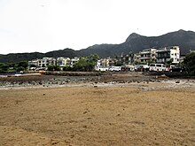
Tseng Tau


Tseng Tau (Chinese: 井頭) is a village of in the Shap Sze Heung area of Sai Kung North, in Tai Po District, Hong Kong, located near the shore of Three Fathoms Cove.
Administration
[edit]Tseng Tau is a recognized village under the New Territories Small House Policy.[1]
History
[edit]The Shap Sze Heung Tsung Tsin Church (十四鄉崇真堂) of the Tsung Tsin Mission of Hong Kong was initially located in the Yat Sun School (日新學校) of Tseng Tau starting from 1954. A dedicated church building was later built in Nga Yiu Tau in 1960. The building is now vacant.[2][3]
Conservation
[edit]Tseng Tau Coast, a coastal area of 1 km in length located north of the village and facing Three Fathom Cove, covering an area of 4.3 hectares, was designated as a Site of Special Scientific Interest in 1994.[4][5]
See also
[edit]References
[edit]- ^ "List of Recognized Villages under the New Territories Small House Policy" (PDF). Lands Department. September 2009.
- ^ Tsung Tsin Mission of Hong Kong. Our story (in Chinese)
- ^ Cultural Heritage of Tai Po (PDF) (in Chinese). Tai Po District Council. 2007. p. 110.
- ^ "Register of Sites of Special Scientific Interest (SSSIs)". Planning Department.
- ^ "Site of Special Scientific Interest - Tseng Tau Coast" (PDF). Planning Department. 30 September 1992.
External links
[edit]- Delineation of area of existing village Tseng Tau (Sai Kung North) for election of resident representative (2019 to 2022)
- Pictures of Tseng Tau Village and Yat Sun School
22°25′39″N 114°16′10″E / 22.427539°N 114.269473°E
